WHAT IS CARTOGRAPHY (or MAPMAKING)?
Cartography is the science of making maps to represent graphically the geographical features of the Earth.
There are two types of cartography:
- GENERAL CARTOGRAPHY: produces topographical maps.
- SPECIAL OR THEMATIC CARTOGRAPHY: produces political, economic maps, road maps...
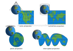
WHAT IS A MAP?
A map is a drawing representing the Earth's surface or a part of it.
WHAT IS A STREET PLAN?
A street plan is a graphic representation of an urban area.
WHAT IS A STREET PLAN?
Mapmakers use symbols and colours to represent real things, for example: towns, cities, roads, etc.
The meaning of these symbols and colours is explained in the legend.
Symbols thar represent similar things are grouped together (for example, they are shown in the same colour).
In addition, symbols are listed in rank order (for example, the symbol for the largest cities appears first; the symbol for the smaller cities follows).
Cartography is the science of making maps to represent graphically the geographical features of the Earth.
There are two types of cartography:
- GENERAL CARTOGRAPHY: produces topographical maps.
- SPECIAL OR THEMATIC CARTOGRAPHY: produces political, economic maps, road maps...
WHAT IS A MAP?
A map is a drawing representing the Earth's surface or a part of it.
WHAT IS A STREET PLAN?
A street plan is a graphic representation of an urban area.
WHAT IS A STREET PLAN?
Mapmakers use symbols and colours to represent real things, for example: towns, cities, roads, etc.
The meaning of these symbols and colours is explained in the legend.
Symbols thar represent similar things are grouped together (for example, they are shown in the same colour).
In addition, symbols are listed in rank order (for example, the symbol for the largest cities appears first; the symbol for the smaller cities follows).